The airspace above Oberstdorf and the Nebelhorn as an interactive 3D flight map.
⚠️ Demonstration and training only. Not flight preparation, not a weather briefing, and not an authoritative source of airspace information.
What it does
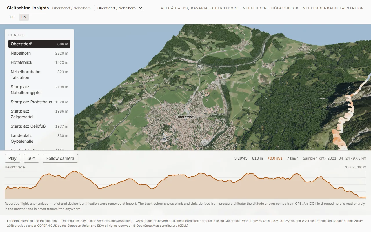
A Microsoft Fabric App that renders 9 × 8 km of the Allgäu Alps at true scale from official 1 m terrain data, surrounds it with 30 km of coarse terrain so the horizon is a mountain range rather than a cliff edge, and replays real paraglider flights over it.
The subject is paragliding. The point is Fabric — Real-Time Intelligence, Direct Lake, Notebooks and Pipelines, and above all the Fabric App itself as the delivery vehicle. The Allgäu is what makes people lean forward; Fabric is what they take home.
Four things you can do with it:
- Look at the mountain. Oberstdorf at 813 m, the Nebelhorn at 2 224 m, 1 400 m of relief between them, at true scale with no vertical exaggeration.
- Replay a flight. The track draws itself coloured by climb and sink, the barogram doubles as the scrubber, and the wind is derived from the flight's own thermal circles.
- Watch who is flying right now. (Phase 4.) Live FANET/FLARM traffic when the sky cooperates.
- Ask it questions. (Phase 6.) Voice and chat over the same data.
…and then switch the whole thing to a different mountain from the dropdown in the header.
Two sites, one build
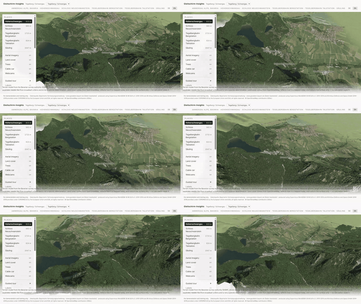
The location is configuration. Two areas of interest ship:
| Oberstdorf / Nebelhorn | Tegelberg / Schwangau | |
|---|---|---|
| URL | / |
/?aoi=tegelberg |
| Core | 9.6 × 8.5 km | 7.7 × 7.4 km |
| Relief | 813–2224 m | 773–2047 m |
| Registration residual | −0.44 m median, 79 peaks | −0.94 m median, 33 peaks |
| Buildings / trees | LoD2 + canopy | 3736 / 229 007 |
| Bundled flight | yes | none — and it shows none |
Adding the second one cost one JSON file and no new data-source code: same LDBV tiles, same
Copernicus shell tile, same Overpass queries, same renderer. What it did cost was five places
where the app had quietly hard-coded the first site — the guided tour, the bundled flight, a layer
label, the tab title and the canvas description for screen readers — none of which looked wrong on
screen. e2e/aoi.spec.ts now pins all five. See PLAN §4.4.
The Tegelberg deliberately ships no flight: the archive contains none over it, and borrowing Oberstdorf's would mean drawing a precise, plausible, entirely fictional track through the wrong valley.
Everything is built from openly licensed data, registered in NOTICE.md before use. The framing and content rules are binding and live in PLAN.md §2 — they outrank every other part of this repo.
Getting started
You need Node 20+, Python 3.11+, and about 380 MB of download budget for the geodata.
npm install
pip install -r tools/requirements.txt

python tools/geodata/pipeline.py   # downloads and derives terrain, land cover, buildings, cableway
npm run dev                        # http://localhost:5173
A fresh clone has no terrain until the pipeline has run — the derived assets are tens of megabytes and are reproducible from open sources at any time, so they are not committed. That is a normal first-run state and the app says so rather than failing with a fetch error.
The pipeline is resumable and safe to re-run; downloads are cached and verified. It compiles every step and checks its imports before anything is downloaded, so a broken step fails in two seconds rather than after 568 MB. Individual steps, and the second site:
python tools/geodata/pipeline.py --list
python tools/geodata/pipeline.py --only verify
python tools/geodata/pipeline.py --aoi tegelberg   # build the other site
Every generated asset is written per AOI (public/terrain/<aoi>/, data/raw/osm/<aoi>/), so the
two sites cannot overwrite each other's data.
Live traffic and the assistant (optional)
npm run relay        # node server/ogn/relay.js — live OGN traffic, port 8787
npm run voice        # node server/voice/mint.js — realtime voice secrets, port 8788
Two separate processes on purpose: they share nothing and must fail independently — a missing device database should not cost you the assistant, and vice versa. Neither is required. Without the relay, live traffic reports itself unavailable and the recorded flight is shown instead, badged Aufzeichnung; without the voice service the assistant says so. That is also what the deployed build does, because static hosting can hold neither a TCP socket nor a credential.
The voice service mints a ten-minute ephemeral secret from an Azure CLI token and hands only that to the browser, which then talks to Azure AI Foundry directly. No API key exists in this repo, and none reaches the client.
How it is put together
The terrain is two tiers, and the reason is a flight rather than a rendering preference. The one flight in the archive that reaches Oberstdorf spans roughly 20 × 17 km, and a track that runs off the edge of the map looks broken. So a photoreal 9 × 8 km core (LDBV DGM1, LoD2 buildings, land cover, the Nebelhornbahn) sits inside a ~30 × 34 km shell of coarse Copernicus terrain that continues into Austria, where the Bavarian data stops. The shell is also the horizon: without it the most dramatic terrain in Germany reads as a model on a table.
Everything is derived offline and read in the browser. tools/geodata/ turns open geodata into
the assets under public/terrain/; the renderer displaces a plane by a quantised height grid and
colours it. If a number looks wrong, the bug is almost always in the pipeline, not the renderer.
No coordinate is ever recalled. Every place in config/aoi/*.json is resolved from
OpenStreetMap by tools/geodata/resolve_places.py. This is not a stylistic rule — the AOI shipped
for a while with an Oberstdorf 4.6 km from the town, and the thing that caught it was the terrain:
the heightmap put that point at 1115 m against a published 813 m.
The registration gate
tools/geodata/verify_registration.py runs as part of the pipeline and fails the run if the
terrain is not where it claims to be. It compares the generated model against every published summit
elevation inside the AOI — 79 peaks, currently a median residual of −0.44 m with a spread of 3.79 m
and no correlation with easting or northing — and draws a longitudinal profile from Oberstdorf to
the summit.
It is a gate rather than a report because a flight track drawn over a misregistered mountain is worse than no map at all: it looks authoritative.
Repository layout
config/aoi/         area of interest — the only place a coordinate or a place name lives
tools/geodata/      the pipeline: fetch, build, verify
tools/flights/      IGC anonymisation, and curation into the Lakehouse tables
tools/ogn/          the OGN reachability spike — the gate phase 4 had to pass
tools/weather/      ICON-D2 sizing spike and the AOI harvest
tools/fabric/       Lakehouse, Eventhouse, semantic model, verification, Mode D export
server/ogn/         the live relay: APRS-IS client, privacy filter, SSE fan-out
fabric/kql/         Real-Time Intelligence schema
fabric/notebooks/   the scheduled ICON-D2 harvest
src/twin3d/         the renderer — terrain, shell, buildings, cableway, track, live traffic, sky, camera
src/flight/         IGC parsing, vario, and the wind derivation
src/live/           the relay client
src/components/     React shell, barogram, wind profile, live panel, day panel
public/terrain/     generated, gitignored, reproducible
public/flights/     anonymised sample flights — committed on purpose
public/day/         Mode D snapshot, exported from the semantic model
Fabric
The analytical half runs in Microsoft Fabric, and the pieces are provisioned by script rather than by clicking:
npm run curate                                  # IGC -> flight_fix / flight_summary / flight_wind
python tools/weather/harvest_icond2.py          # ICON-D2 -> weather (AOI aggregate)
python tools/fabric/setup_lakehouse.py          # Lakehouse + upload
python tools/fabric/load_tables.py              # CSV -> Delta
python tools/fabric/create_semantic_model.py    # Direct Lake model
python tools/fabric/verify_model.py             # query it and compare against the source
python tools/fabric/export_day.py               # DAX -> public/day/<aoi>.json for Mode D
⚠️ verify_model.py is not optional politeness. A Direct Lake partition pointing at a path that
does not exist frames zero rows and reports no error — every visual is simply empty. The only
honest check is to ask the model questions and compare its answers with the files it was built
from.
Privacy
Live tracking shows real people, so the rules are enforced in the relay rather than in the browser: a pilot who has opted out of the OGN device database is never sent to the client at all, and everyone else arrives without a registration. Aircraft that are not identifiable are given a salted hash rather than their hardware address — the database is public, so forwarding the real device id alongside a blank registration would let any client look the pilot up and undo the flag. The salt is regenerated on every relay start.
Of the 36 126 devices registered when this was written, 350 had opted out of tracking and 472 out of identification. It is not a hypothetical rule.
Before you commit
npx tsc -b        # types
npm run lint
npm test          # unit — IGC parsing, wind derivation, the fact register
npm run test:e2e  # loading and deployment guardrails
Licence
Source code is MIT — see LICENSE. The data is not ours to relicense: terrain, buildings, land cover and imagery are third-party open data with their own attribution requirements, all listed in NOTICE.md. The attribution block must travel with any redistribution or public deployment.
Fabric architecture
npx rayfin up provisions:
- Entra sign-in (Fabric identity)
- Static web app
Project structure
config/         configuration
e2e/            end-to-end tests
fabric/         Fabric item definitions (report, semantic model, eventhouse)
public/         static assets served as-is
rayfin/         deployment config - redirect URIs are loopback only
server/         backend service / relay
src/            the application
tools/          data pipeline and build helpers
Scripts
| Script | What it does |
|---|---|
npm run build |
production build |
npm run build:fabric |
build the bundle Fabric static hosting serves |
npm run curate |
|
npm run data:build |
download and derive the input data |
npm run dev |
dev server on http://localhost:5173 |
npm run dev:fabric |
|
npm run lint |
lint |
npm run relay |
|
npm run test |
unit tests |
npm run test:e2e |
end-to-end tests |
npm run voice |
Data
Sources and their licences are listed in NOTICE.md.
Credits
Third-party data and licences: NOTICE.md. Licence: LICENSE. Copyright (c) Microsoft Corporation..