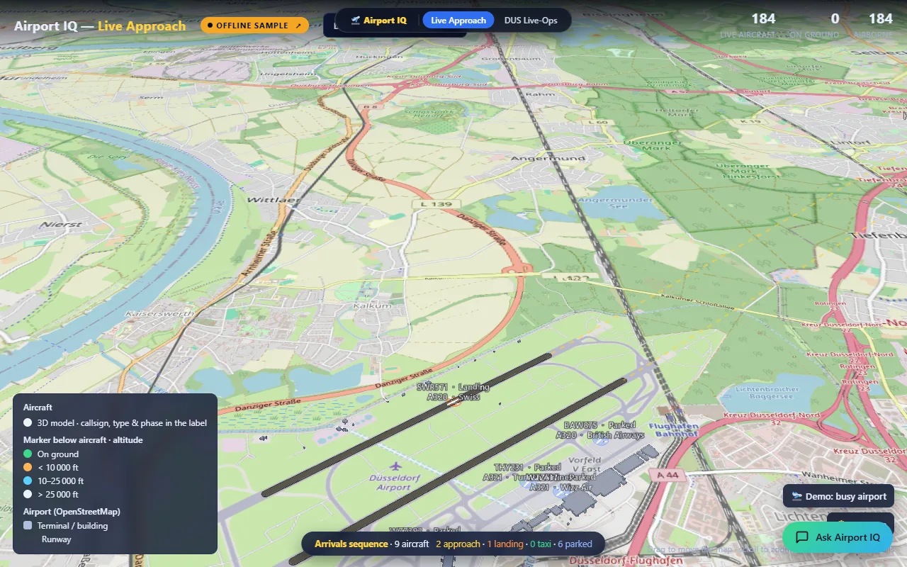
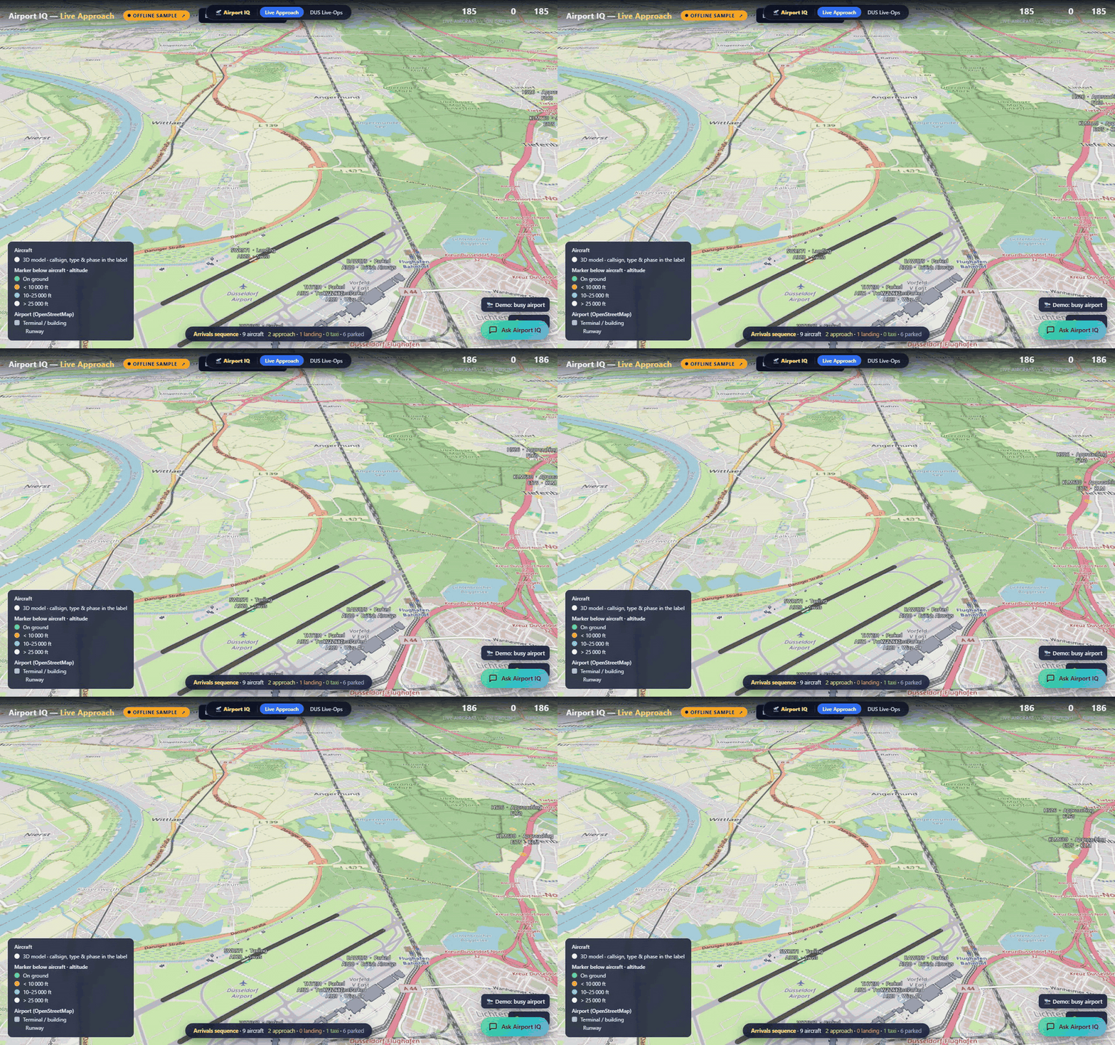
The single, deployed Airport IQ Rayfin static-hosting app. A dark landing page
(index.html) with two tiles that open the two 3D views. This app supersedes the
older four-view apps/archive/airport-iq hub.
- Fabric item:
Airport IQ— AppBackend<app-item-id>(workspace<your-workspace-id>, capacityprdsweden, Sweden Central) - Live URL: <
.webapp.fabricapps.net> - Archive copy:
Airport IQ - Archive(<archive-item-id>, <.webapp.fabricapps.net>) — a superseded snapshot, kept for reference.
What it does
- Live aircraft on approach from the public airplanes.live ADS-B API
- A 3D airport model built from real OpenStreetMap gate geometry
- Two views - the approach, and what is happening on the ground - behind one landing page
The two portions (views) and their data sources
The app bundles two independent 3D views. They use different engines and, importantly, different data sources — one is driven by a live external feed, the other by a pre-generated synthetic snapshot. All geometry (buildings, runways, gates) in both views comes from OpenStreetMap, filtered to the aerodrome boundary.
| ① Live Approach | ② Live-Ops | |
|---|---|---|
| File | views/approach/index.html |
views/liveops/index.html |
| Engine | CesiumJS 1.121 (real 3D globe) | Three.js r160 + OrbitControls (local apron scene) |
| What it shows | Real aircraft on approach → landing → taxi → park, zoomable from orbit to the apron | Gate operations — time-scrubber, docking at real gates, delays, cascading gate conflicts |
| Airports | FRA · MUC · BER · DUS · AMS (dropdown) | DUS · BER only (?ap=DUS / ?ap=BER) |
| Aircraft data | LIVE | Synthetic snapshot |
① Live Approach — data sources
Real-time, external, per-airport. Nothing here is stored aircraft data — it is polled live.
- Live aircraft (real-time): the public airplanes.live ADS-B REST API —
GET https://api.airplanes.live/v2/point/{lat}/{lon}/180, polled every 15 s. Positions, altitude, ground-speed, track, hex and type come straight off the live feed and are driven through the approach/land/taxi/park choreography.- Offline fallback: if the API is unreachable,
views/approach/data/live.json(a captured sample) is used so the view is never empty.
- Offline fallback: if the API is unreachable,
- Base map: OpenStreetMap raster tiles (
https://tile.openstreetmap.org/{z}/{x}/{y}.png) — no Cesium Ion token, no terrain. - Airport geometry:
views/approach/data/<IATA>.geojson— extruded OSM building footprints, runways and gates, filtered to the airport's OSM aerodrome boundary. One file per airport:FRAMUCBERDUSAMS. DUS additionally carries OSM taxiway centrelines (kind:"taxiway"line features) that the arrival taxi router follows (see below). - Airport manifest:
views/approach/data/airports.json— the focus list + each airport's centre lat/lon and elevation (used to centre the globe / camera).
② Live-Ops — data sources
Fully synthetic and pre-generated — no live feed. The operational schedule is the Airport IQ operational model repositioned onto the airport's real OSM geometry.
- Operations snapshot:
views/liveops/data/<AP>/snapshot.json— the synthetic schedule:gates,airlines,airports,flights,assignments,delays,conflicts, plus ametatime window. Its ownmeta.sourcerecords the provenance, e.g. "Airport IQ operational model repositioned onto Düsseldorf OSM geometry (real gates)". - Buildings:
views/liveops/data/<AP>/buildings.json— OSM footprints, aerodrome-filtered. - Runways:
views/liveops/data/<AP>/runways.json— runway centrelines (two parallel runways per airport: DUS05R/23L+05L/23R, BER06L/24R+06R/24L). - Available only for
DUSandBER(the two airports for which the operational snapshot exists).
Data-source summary
| Data | Source | Type | Used by |
|---|---|---|---|
| Live aircraft positions | airplanes.live ADS-B API (poll 15 s) | Live external feed | Live Approach |
| Aircraft fallback | approach/data/live.json |
Captured sample | Live Approach |
| Base map tiles | OpenStreetMap | Live external tiles | Live Approach |
| Buildings / runways / gates | OpenStreetMap (aerodrome-filtered geojson/json) | Static (from OSM) | both views |
| Gate-operations schedule | Airport IQ synthetic operational model | Static snapshot (generated) | Live-Ops |
Live Approach — behaviour & features
views/approach/index.html — a CesiumJS globe over OSM tiles, centred on
one airport (dropdown / ?ap=), showing two layers of aircraft:
- Live ADS-B layer — every real aircraft within 180 nm of the airport, polled from airplanes.live every 15 s and dead-reckoned between polls. Coloured by altitude (on-ground / <10k / 10–25k / >25k ft), billboard sized by aircraft family.
- Arrivals choreography — a rolling sequence of arrivals that fly the full approach → land → taxi → park cycle, up to 12 at once.
Verifying the data is real (so you can check nothing is faked):
- The header "Live ADS-B ↗" badge is a link to the airplanes.live live map for the same airport
(
globe.airplanes.live/?lat&lon&zoom). The badge also shows the current data source at a glance: 🟢 green Live ADS-B = live feed, 🟠 amber Offline sample = the API was unreachable so the captureddata/live.jsonsample is shown, 🔴 red No live data = neither source responded. - Clicking any live aircraft opens an info box with a "Verify → airplanes.live ↗" link straight to that exact aircraft by its ICAO hex.
On-map labels (no click needed): each aircraft shows callsign + aircraft type (ICAO code
prettified, e.g. A388→A380, B77W→777-300ER) + carrier (ICAO airline code → name, ~60 carriers;
registration-style callsigns show no carrier rather than a wrong guess).
Movement realism: phase durations are distance-based at realistic ground speeds (approach ≈175 kt, taxi ≈47 km/h), so speed stays correct regardless of route length. Arrivals use two-runway ops (longest runway + a parallel sister) and realistic per-airline fleets for the synthetic callsign/type pairs.
Taxi routing (TAXI module): after landing, each arrival taxis to its stand along a building-avoiding,
taxiway-following route — a visibility graph over building-corner nodes plus the OSM taxiway network
(taxiway edges are discounted so Dijkstra prefers real centrelines). Validated on DUS: 0 building crossings,
~65 % of each path on real taxiways. Airports without taxiway data fall back to pure building-avoidance.
Stands are pushed clear of every terminal footprint (parkFix) so no aircraft parks inside a building.
Camera: a floating 🖐 Pan map / ⟳ Orbit airport toggle switches between free globe panning and orbiting the focus airport; scroll to zoom from orbit down to the apron.
Live-Ops — behaviour & features
views/liveops/index.html — a Three.js apron scene for DUS/BER driven by the
synthetic operations snapshot. Time-scrubber to see gate occupancy over the schedule window; gate pads
coloured free / occupied / delayed / conflict; aircraft rendered as 3D meshes (fuselage sized by
family, airline-coloured tail fin) that read correctly from any camera angle. Parked aircraft are placed
nose-in on the apron, pushed clear of the terminal footprints (no fuselage buried in a pier). Optional
auto-rotate; click a gate for flight/airline/route detail.
Build & deploy
cd apps/live-approach
npm run build:fabric        # assembles fabric-dist/ (tools/build-fabric.mjs)
npm run rayfin:up           # deploy to Fabric static hosting
In this workspace deploy via the shared Rayfin binary (the app's own npm install token is expired):
cd apps/live-approach
..\airport-3d\node_modules\.bin\rayfin.cmd up `
  --workspace-id <your-workspace-id> `
  --tenant ${FABRIC_TENANT_ID} -y
Rayfin does not set the Fabric item
displayNamefromrayfin.yml; PATCH/items/{id}{displayName}separately if the tile name needs to change.
Fabric architecture
npx rayfin up provisions:
- Entra sign-in (Fabric identity)
- Static web app
Getting started
npm install
npm run serve
npx rayfin up --workspace-id <your-workspace-guid> --tenant <your-tenant-guid>
Any workspace or item id this app needs is read from the environment, with no default.
Project structure
media/          demo video, GIF and stills
rayfin/         deployment config - redirect URIs are loopback only
server/         backend service / relay
tools/          data pipeline and build helpers
views/
Scripts
| Script | What it does |
|---|---|
npm run build:fabric |
build the bundle Fabric static hosting serves |
npm run rayfin:up |
deploy to your Fabric workspace |
npm run serve |
serve locally |
Credits
Part of Fabric-Apps, MIT licensed.
Data
airplanes.live ADS-B and OpenStreetMap, both public feeds. No tenant data.